Este producto sufre disponibilidad limitada. En caso de que quedara descatalogado, podrían seguir estando disponibles accesorios, recambios, u otros servicios.
Resumen
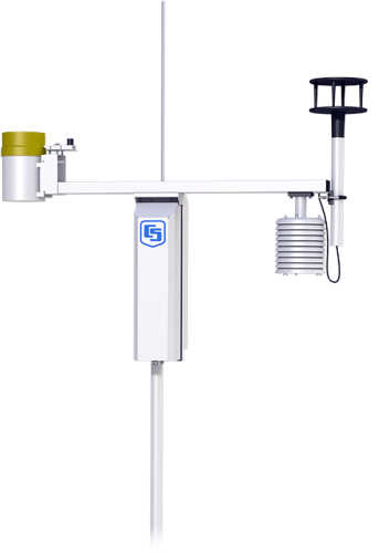
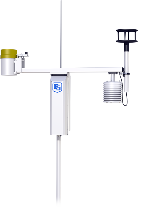
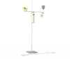
Our ET107 ETo station consists of meteorological sensors, an aluminium 3 m pole, and an environmental enclosure that houses a CR1000M module and a 7 Ahr sealed rechargeable battery. The battery is recharged via an ac transformer or a 10 W solar panel. Sealed circular connectors are provided on the outside of the enclosure to simplify sensor hookup.
Leer másImágenes

Ficheros CAD:
Descripción detallada
Our ET107 ETo station consists of meteorological sensors, an aluminium 3-m pole, and an environmental enclosure that houses a CR1000M module and a 7-Ahr sealed rechargeable battery. The battery is recharged via ac power or a 10-W solar panel. Sealed circular connectors are provided on the outside of the enclosure to simplify sensor hookup.
Meteorological sensors included with the ET107 are the CS305-ET Solar Radiation Sensor, HMP60-ETS Air Temperature and Relative Humidity Probe, TE525-ET Tipping Bucket Rain Gauge, and either the 034B-ETM Wind Set or WindSonic1-ETM 2-D Sonic Wind Sensor.
The ET107 can also measure the:
Preguntas frecuentes
Número de FAQs relacionadas con ET107: 16
Expandir todoDesplegar todo
-
Refer to the “Maintenance, Troubleshooting, and Schematics” section of the ET107 Weather Station Instruction Manual for procedural instructions.
-
Wind speed, wind direction, solar radiation, temperature, relative humidity, and rain measurements are data parameters that are available. Typically, ETo is calculated by the software; however, it is possible for the ET107 to perform the calculation as well.
-
Campbell Scientific recommends the following maintenance schedule:
- Once a week: check the rain gage funnel, and clean as necessary.
- Once a month: check the solar radiation sensor, and clean as necessary.
- Every 3 months: clean the temperature/RH radiation shield.
- Every 6 months to 1 year: replace the two desiccant packs (pn 4905).
- Every 1 to 3 years: have Campbell Scientific replace the wind speed bearings and reed switch. Request a return material authorization (RMA) number by following the steps listed on our Repair and Calibration page.
- Every 1 to 3 years: replace the relative humidity chip (pn 9598).
- Once every 3 years: have Campbell Scientific calibrate the solar radiation sensor. Request a return material authorization (RMA) number by following the steps listed on our Repair and Calibration page.
- Once every 5 years: have Campbell Scientific calibrate the rain gage sensor. Request a return material authorization (RMA) number by following the steps listed on our Repair and Calibration page.
- Once every 5 years: have Campbell Scientific calibrate the data logger. Request a return material authorization (RMA) number by following the steps listed on our Repair and Calibration page.
-
Calsense Command Center software can interface with Campbell Scientific’s VisualWeather software, which can retrieve values from the ET107. In the Command Center software, setting up a station involves connecting to the VisualWeather LoggerNet server and selecting variables from the weather station’s listing for wind speed, rainfall, and ETo.
-
The communications options include direct serial connection, short haul modem, analog phone modem, cellular phone modem, radio, and Wi-Fi. Also, with an enclosure alteration, an Ethernet port can be added.
Note: Some of the listed telemetry options can drastically alter the power budget of the station.
-
Yes. However, special data logger programming is required. Contact an application engineer at Campbell Scientific for assistance.
-
The most significant difference is that the retired ET106 used the CR10X datalogger, whereas the ET107 uses the CR1000 datalogger. Other differences are the following:
- As a design improvement, the ET107 has a seal incorporated into its lid assembly.
- The ET107 uses a CS300 pyranometer instead of the LI200X pyranometer.
- The ET107 provides a choice of wind sensor (either the 034B or the WindSonic1), whereas the ET106 could only be used with the 034B.
-
The PS100 power supply that’s in the ET107 specifies a charging voltage of 15 to 28 Vdc or 18 Vac RMS. A 24 Vac transformer will blow the protective circuitry in the PS100.
Compatibilidad
Replacement sensors for the ET107 have a -ET or -ETM suffix. These sensors are listed under Ordering.
The ET107 can also measure the:
Especificaciones
| -NOTE- |
The ET107 has components that have their own specifications. To review these specifications, refer to the appropriate products below: |
Documentos
Descargas
ET107 Default Programs (4 KB) 29-03-2021
One default program is for an ET107 with the 034B wind sensor and another default program is for an ET107 with a WindSonic1.
ET107 ETsz Example Programs (290 KB) 23-06-2021
The ETsz() instruction requires the user to input lattitude, longitude, elevation, and crop type for a station's location in order to generate accurate calculations of ET. The Generic_ET_107_ETsz.CR1 and Generic_ET_107_ETsz_Windsonic.CR1 programs use the ConstTable() intruction to create a constants table that allows the user to easily input these values using Loggernet, PC400, or a keyboard display. These values only need to be set once, during station set up.
Casos de aplicación

According to a report from the United States Golf Association (USGA), the average golf course......leer más