How to Fill the Road-Weather Information Gaps
por John Markham | Actualizado: 08/13/2019 | Comentarios: 0
Although there have been vast improvements in our ability to gather and use road-weather data, there are still, unfortunately, significant information gaps we must fill. In this blog article, we’ll look at the issues that hinder our current data acquisition and a solution for obtaining more complete and representative data, leading to better-informed decisions.
Historically, we have made road-maintenance decisions based on experience alone. As time has advanced, new technology and predictive modeling have more fully illuminated our decision-making landscape regarding road maintenance. For example, meteorological forecasts and Road Weather Information Systems (RWIS) now provide additional data to help winter maintenance personnel make more informed decisions, which result in better-utilized budgets and improved public services.
Yet, as we look more closely at RWIS capability and practicality, we realize we need a better solution.
ESS Issues
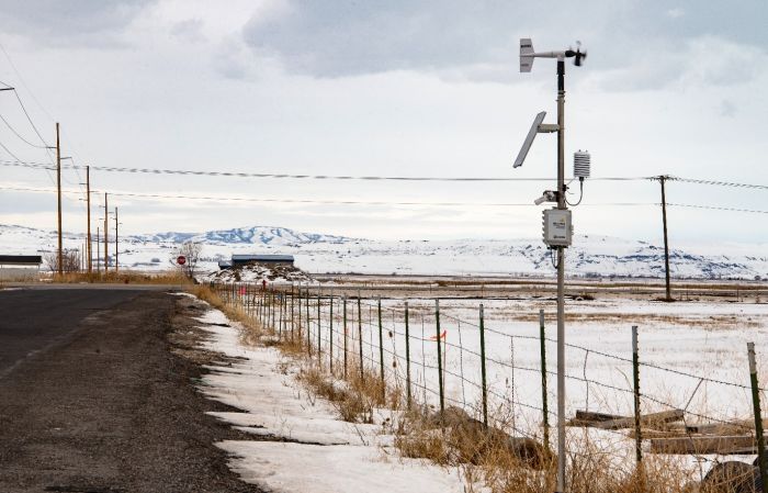
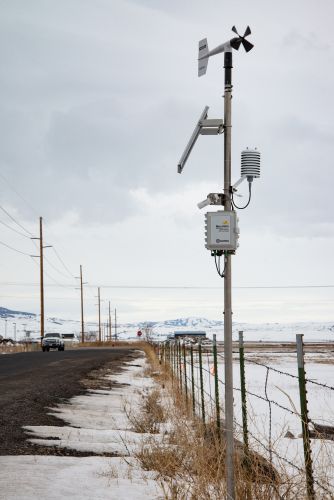
The primary component of an RWIS is the Environmental Sensor Station (ESS). The ESS provides the long-term data necessary to track how road conditions respond to weather events and maintenance efforts in real time.
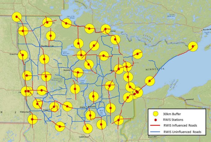
The siting of ESS is critical to the success of the RWIS. The most widely adopted reference for locating ESS is the RWIS siting guideline made available by the Federal Highway Administration (FHWA) in 2008. This guideline recommends an average ESS spacing of 30 to 50 km (18.6 to 31.1 mi) along a roadway (Garret et al. 2008).
As an example of ESS spacing, let’s look at the state of Minnesota. This state is heavily invested in RWIS and, as a leader in the industry, has an excellent network of ESS across the state. Even with these advantages, to provide appropriate coverage for an area as large as Minnesota (225,181.3 km2 [86,943 mi2]) is a daunting task (Kwon and Fu 2016).
The Cost of Representative Coverage
Each time funding becomes available for a new ESS, we must identify the best location for the station. Unfortunately, finding the ideal locations for ESS isn’t as simple as dropping them on a map and making the coverage zones overlap. Moreover, we often have to make compromises regarding siting restrictions and budget constraints. For example, we may have to assign each ESS a large and often dynamic region that it cannot adequately provide representative coverage for.
Not only is it difficult to find ideal locations for ESS, but it takes the efforts of many to identify them correctly. The effective siting of an ESS requires consideration of not only meteorological representativeness and common locations for dangerous weather conditions, but also non-weather-related requirements such as traffic volume, road type, and historical accident rates. To collect this data requires us to gather input from meteorologists, traffic engineers, local maintenance crews, and other industry experts. Additionally, we must consider the availability of power and communications lines (Buchanan and Gwartz 2005).
Even if we know the ideal locations for a perfect distribution of ESS, the ability to achieve that density may be financially impossible. Capital costs of the typical ESS average $90,000 (USD). This amount includes instrumentation hardware, station installation, additional power and communications lines, lane closures, and training. Recurring costs for updating ESS hardware every five years averages $10,446, and standard station maintenance averages more than $5,000 a year.
If we add together the startup costs (including initial purchase and installation) and the operation and maintenance expenses, the cost of a single ESS spread out over an assumed 25-year lifetime is $11,149 per year (Kwon and Fu 2016).
Of course, these amounts can vary widely based on individual circumstances and vendors. It is obvious, however, that even in the best circumstances, the addition of an ESS requires a significant capital cost and recurring maintenance expenses—including the time of technicians and engineers.
Inconvenient Installation
Installing a traditional ESS is no simple feat. The installation requires a 30 ft (9.14 m) tower with a large concrete foundation. Additionally, we must consider the depth of the road shoulder, clear zones, and right of way. Moreover, as mentioned earlier, it’s likely that assistance is needed from a variety of industry experts.
Significant Power Requirements
Standard ESS can have a large variety of sensors as well as communications and data collection hardware—some of which have significant power requirements. To keep these stations running, standard ESS require AC power or substantial alternative power systems. This can be problematic if we have identified locations as high value, but these locations do not have available AC power.
The Solution: Mini-RWIS
To achieve the required density of ESS to effectively measure an entire road network, we cannot continue to do business as usual. We must either significantly increase available funding or explore measurement options that are lower cost and more focused (such as Mini-RWIS).
The premise of a Mini-RWIS station is to balance ESS density with expense and complexity. The improved data and network clarity show promise in reducing costs for transportation authorities and increasing the quality of services provided.
Providing Cost-Effective Coverage
A Mini-RWIS station is similar to a traditional ESS with some important differences. Mini-RWIS are smaller, lower-cost independent stations with less-stringent siting requirements and focused measurements on key road-maintenance parameters. They operate without the need for an AC power connection or complex siting requirements typical of a larger ESS.
These benefits enable us to deploy Mini-RWIS stations in larger numbers and in locations that have heretofore been inaccessible to our standard RWIS. Not only can we record measurements in locations where the use of traditional ESS is not possible, but, at a lower cost, we can deploy Mini-RWIS in sufficient numbers to achieve the density required for the measurement of an entire road network.
Mini-RWIS increase the value of our existing road condition models by filling the gaps in existing networks and expanding their ability to provide high-resolution forecasting for accurate decision making. With a tight network of stations, independent verification of rapidly changing conditions is allowed, which decreases our response time to incoming weather and enables us to identify smaller-scale issues that might otherwise go unnoticed.
Simple Installation
A Mini-RWIS station mounts on any 2 in. (5.08 cm) mast, a quick-install frangible pole, or an existing sign or utility pole. Because of the ease and simplicity of mounting a Mini-RWIS, we can use it for temporary installations for public works projects or for specific or seasonal conditions such as burn scar monitoring.
Reduced Power Needs
The Mini-RWIS has been designed to succeed in low-power situations. For example, a typical Mini-RWIS station runs on a 10 W solar panel in a small enclosure and requires minimal maintenance.
System Integration
For a Mini-RWIS to be valuable as a gap-filling station, it must integrate easily with our existing RWIS. NEMA (National Electrical Manufacturers Association) initiated the development of the NTCIP (National Transportation Communications for Intelligent Transportation System Protocol) specifically for these situations. Mini-RWIS stations include cellular modems and Ethernet access, and they are NTCIP compliant. After the station is provided with the proper IP configuration, we can poll it directly from any system that uses NTCIP. We can also configure Mini-RWIS to push data out through various common protocols (for example, FTP, HTTPS, SMS, etc.).
Conclusion
To meet the measurement density requirements necessary for a complete picture of a road network, our individual stations must be cost effective. By taking advantage of existing infrastructure and communications capabilities, Mini-RWIS stations are an order of magnitude less expensive than their traditional counterparts.
Mini-RWIS provide key measurement data on a solar platform that we can deploy in previously inaccessible locations. The modularity of Mini-RWIS stations allows DOTs to efficiently pinpoint sites where additional focused monitoring is required for local dangers such as flooded roadways, crosswinds, visibility, or high-traffic-incident locations.
Enhancing an existing RWIS with Mini-RWIS increases our measurement density and provides greater temporal and spatial coverage of the road network. With this information, we can make well-informed decisions as we strive to keep our roads clear and safe.
To learn more about enhancing an RWIS with Mini-RWIS, read our case study. If you have any questions or comments about Mini-RWIS, post them below.
References
Buchanan, F. and Gwartz, S. E. 2005. Road Weather Information Systems at the Ministry of Transportation, Ontario. 2005 Annual Conference of the Transportation Association of Canada, September 18–21, Calgary, Alberta.
Garrett, J. K., Boyce, B., Krechmer, D., and Perez, W. 2008. Implementation and Evaluation of RWIS ESS Siting Guide. Road Weather Management Program, Federal Highway Administration, Washington, DC, and Research and Innovative Technology Administration, U.S. Department of Transportation, Washington, DC.
Kwon, T. J., Fu. L. 2016. RWIS Network Planning: Optimal Density and Location. Aurora Program, Iowa State University, Ames, IA. https://intrans.iastate.edu/app/uploads/2018/10/RWIS_network_planning_for_optimal_density_and_location_w_cvr.pdf


Acerca del autor
 John Markham is a Product Test Specialist at Campbell Scientific, Inc. His expertise includes Road Weather Information Systems (RWIS) and serial protocols. He contributes to the greater road weather community by serving on the NTCIP working group and the AMS committee on surface transportation. John has a master’s degree in physics and instrumentation. In his downtime, he enjoys board games and historical reenactment.
Comentarios
Please log in or register to comment.